View layers and turn on/off a layer under a Layer Category
|
The Public Web Map utilizes map layers to control what details you can see or cannot see at any given time. By using the Layer Configuration Tool you can customize what layers and information you wish to see on the map. Why would you use this? If you want to see map information that is not displayed, or would like to hide map information that is not relevant to you, this help video is for you! For example you can turn provincial roads on or off, or lakes and streams depending on what you wish the map to convey. |
|
Layers under a Layer Category
- All layers on the Operational Layers list are essentially Layer Categories.
- There are sub-layers under each Layer Category.
View layers under a Layer Category
- Click on the expand arrow for a certain Layer Category, as shown in Figure.1.
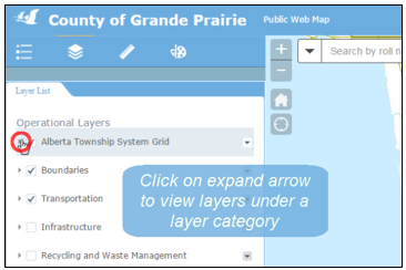
Figure.1
- For each single layer, there is also a checkbox controlling its visibility. Turn on/off this layer by checking/unchecking the checkbox, as shown in Figure.2.
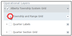
Figure.2
Created with the Personal Edition of HelpNDoc: Streamline your documentation process with HelpNDoc's WinHelp HLP to CHM conversion feature